
Sierra de Oltà - the neighbour of the Calpe cliff
- Admin
- Oct 20, 2023
- 6 min read
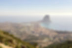
A few kilometers from the Calpe cliff is a mountain peak that rises 589 meters above sea level - la Sierra de Oltà or Serra D'Oltà.

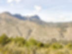
From the top there is a view to the Calpe cliff to the south, the Sierra Bernia to the west and El Montgo to the east.

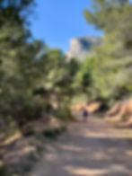
The tour starts at the car park at Zona Recreativa Serra D'Oltà, which is 220 meters above sea level.

Follow the route PR-CV 340.

Study the map on the notice board before you start your trip. You can choose several routes. In this post, two of them are described - 1) back and forth to the top, and 2) round trip around the mountain.

To the top: The trip to the top goes from point 1-16 on the map. The trip back down goes from point 16-20 and from there to point 10 along a road marked in gray on the map, and then from point 10-1 back to the car park.

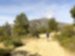
The route is marked yellow and white. The first kilometer is on a gravel road with a relatively steady incline. Follow the signs to La Ermita Vella.


Follow the sign for Ermita Vella also when you get the option to choose a path to the right that goes to Cim D'Oltà.


Along the way, you get a good view of Calpe town, the small lake Les Salines de Calpe and the Calpe cliff.

First destination is the chapel La Ermita Vella de Sierra de Oltà. It takes approx. 25-40 minutes. If you have small children with you, a trip back and forth here may be enough.

Here there is a recreation area with benches, bins and toilets, but remember to bring toilet paper because there is none on site.

From La Ermita Vella, the route continues on a gravel road up to the summit Cim D'Oltà. Always follow the signs for Cim D'Oltà.

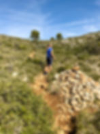
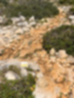
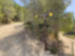
After approx. After 200 metres, turn left onto a path that leads relatively steeply upwards. The sign in the picture below can only be read from the back. The path is marked yellow/white.

On this stretch, you occasionally have to use your hands to help you get up, but there are no dangerous or scary parts.
You quickly get a nice view of Calpe and eventually of the surrounding mountain areas.

After approx. 30 - 45 minutes you will reach a plateau. Here you can see Benidorm in the west.

Follow the yellow/white markings and signs for Cim further on for approx. 10 - 15 minutes.
Then you arrive at the ruins of a disused farm. Here you can go two ways to the top because a round trip has been made - see points 14, 15, 17 on the map - but it is best to go the right part of the loop up and the left back down.

Therefore follow the sign for Cim D'Oltà on the right. The route up to point 15 on the map takes approx. 10 - 15 with a relatively steady rise.

At point 15 on the map, there is a crossroads. The signs show the two roads you can take to get back down to the ruins (point 14 on the map). The path straight ahead leads to the summit. It is not marked, but easy to see in the terrain.

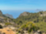
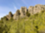
After just 100 metres, you reach a peak that offers a nice view of all the surrounding mountains. However, the path continues for a few hundred meters to the formal summit.

From here you can see Benidorm and the Sierra Helada to the west, the Calpe cliff and the surrounding areas in the south.

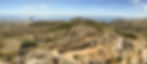


In the north-west direction you see the Sierra Bernia.

In the eastern direction you see El Montgo - also called Elephant Mountain by the coastal town of Dénia.


On the way back down, choose the path to the right, the opposite of the one you came up. It leads back to the ruins at point 14 on the map.

Here you can see wild goats or sheep if you are lucky.


After walking for 10 minutes and approaching the ruins, you will come to a crossroads. There you choose the path to the left so that you come all the way back to the sign at the ruins.
Then follow signs to Pou de la Mola and Circuit Principal. It is a narrow path in forest terrain.


After 10 - 15 minutes you will reach new ruins - Pou del la Mola.

At this crossroads you can continue on a path straight ahead that leads to Ermita Vella 1550. This is a narrow forest path in rough terrain. If you choose to follow the Circuit Principal sign, you get a slightly longer, but more pleasant way back to Ermita Vella.

You then continue down a forest path for approx. 5 minutes until you reach a dirt road. Here you turn left and follow the sign for Ermita Vella. Ignore the white/yellow cross which usually means this is a path you shouldn't follow.

You will then walk the rest of the way back on a gravel road with a nice view. This is the ornithological route where you can see many different bird species. It takes approx. 20 minutes.

Option 2 - Round trip. Follow the signs from the parking lot to Ermita Valle, that is from points 1 - 9 on the map. Then go to point 10 and turn left there onto a gravel road marked in gray on the map. Follow this to point 20. Then continue from point 20 to point 29 and back to point 1, the car park.

Walk approx. 50 meters up the road to Cim D'Oltà from Ermita Valle. Here you turn left towards Oltà Sud and La Canal.
This is the Ruta ornithologica - an ornithological route where you can see many bird species. It is a gravel road that is easy to walk on mostly flat terrain. At point 20, there is a sign. Here you can go to the top via Pou de la Mola, but to follow the route, go straight ahead towards La Canal.

From now on, you must follow the signs for either La Canal or Zona d'Acampada (the car park). The route is marked white/yellow PR-CV 340.

You walk on a dirt road until you reach point 23 on the map, which marks the ruins of the Finca Pastor farm where you have a view of the Sierra Bernia on the left. This is a nice place for a break.
After the break you follow the road upwards through a sharp right turn signposted to Zona D'Acampada.
The route has a dirt road for a bit, but then it turns into a path, and the rest of the trip is on a narrow path through forest terrain.

In the last part of the route that goes through the El Canal pass, there is a relatively steep descent in slightly rough terrain where you occasionally have to use your hands for support, but there are no dangerous or scary parts.
You can choose several routes in the Oltà mountain depending on your wishes and physical performance. All routes are safe, well signposted and relatively easy.
1. Hike to Ermita Valle. About 25 - 45 minutes up a moderate incline and approx. 20-35 minutes back. From points 1 - 9 on the map. Slightly strenuous climb, but nice gravel road the whole time. About 50 minutes in total.
2. Hike to the summit Cim D'Oltà. 3.5 km each way, a total of 7 km. From point 1 to 16 and from 16 to 1 on the map. There is a section with a relatively steep climb on the path, where in some places you have to use your hands for support. In this part it can be strenuous on the way up and a bit demanding down again. About 2.5 - 3 hours.
3. To the top Cim D'Oltà with return via Ruta ornithologica. From point 1 to 16 upwards. From point 16 to 20 down to Ruta ornitologica, then point 20, point 10 and 9 - 1 down. 3.5 kilometers up and 6 kilometers back. The ascent can be strenuous, but the descent is pleasant. About 3 - 3.5 hours.
4. To the top Cim D'Oltà with return via Circuit principal. From point 1 to 16 on the map upwards. From point 16 to 20 downwards. Then from points 20 to 29 back to the car park. 11.5 kilometers. Somewhat strenuous ascent, but pleasant route return. About. 3.5 hours.
5. Hike to Finca Pastor. From points 1 to 9 (Ermita Valle). Then from point 10 directly to point 20 and from there from 20 to point 23. Approx. 2 - 2.5 hours on a dirt road. Pleasant route.
6. Round trip. From point 1 to point 10. Then the gray dotted road on the map directly to point 20, and then from point 20 to point 29. Mostly on dirt roads. Forest path on the last part where there is also a steep descent where you have to use your hands to help. Safe and comfortable route. 10.5 kilometers. About. 3 hours.
More excursions: www.turideer.com
Excursion of the week: Sierra de Oltà
Suitable for: Options 1 and 5 are suitable for everyone, even small children. Alternatives 2, 3, 4 and 6 are suitable for people in normally good physical shape.
Get there: Search for Zona d'Acampada de Oltà. You will then come straight to the car park. Otherwise: Drive the N-332 from Altea to Calpe. Take off for Calpe. Turn at the first roundabout and drive back under the bridge in the lane towards Alicante. Just after the bridge, you continue straight ahead instead of turning left towards Alicante. Then follow the signs for Oltà until you reach the car park at Zona d'Acampada. There is a relatively steep climb on narrow roads.