
Herna at Peña Negra Crevillente - the Phoenicians on the black rock - archaeological route - hike in protohistory
- Admin

- Nov 22, 2025
- 10 min read
Between the ninth and sixth centuries BC, the Phoenicians had a large city called Herna in an area of the Sierra de Crevillente mountain range in Spain. An archaeological excavation has provided a lot of information about how the city was organized. It was a whopping 40 hectares and was surrounded by a strong wall. Today, this is a great destination for a hike where you can learn about the history on an archaeological route while walking in a beautiful and distinctive mountain landscape.

The Phoenicians originally came from the land of Phoenicia, a small coastal strip that stretched across present-day Lebanon, northern parts of Israel, and western parts of Syria. It is also called the land of Canaan, which means lowlands. Due to a lack of fertile land, they eventually traveled by boat and established colonies all around the Mediterranean coast. They developed great expertise in navigation and became skilled seafarers.

In Spain, they had colonies along the eastern coast from the eleventh to the fourth century BC. The first colony was formed around the year 1000 in what is now Cádiz. Here the Phoenicians established a coastal city that became an important hub for trade in the Mediterranean. In the ninth century BC, they established a colony at what is now Peña Negra in the Sierra Crevillente. It became a city with an advanced structure and organization. The city, which eventually took the name Herna, was protected by a 1.5-meter-wide and several-meter-high wall and a fort located on top of Peña Negra with a good view of large mountain and land areas around and the Mediterranean Sea to the south. Peña Negra means the black rock, a name it received because of the dark gray color of the bedrock created by carbonates from the Jurassic period.


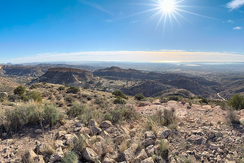
The Phoenicians of Herna made their living through agriculture, cattle breeding, metal mining and trade. Due to geographical conditions, cattle from the southern parts of Spain were driven along the plains below Peña Negra when they were transported to the eastern parts of Spain. This makes it easier to understand why they built a city high in the mountains far from the sea. Peña Negra is located between the mouths of the two large rivers, the Segura and Vinalopó, and was an important hub for transport both by land and by sea. From their vantage point on Peña Negra, they could observe the cattle transport on the plains. They could also observe the boat traffic on the sea, which was much closer to the mountains at that time, and in the mouths of the two rivers, which had a much greater flow than today.


The Phoenicians had a great influence on the Iberian population of Spain. They brought with them important technology and knowledge of boatbuilding and navigation, the extraction of metals, the production of tools and weapons, agriculture, and the organization of trade and society. They also brought with them the knowledge of making olive oil and wine, products that are still important to the Spanish economy. Last but not least, they brought with them the skills of reading and writing. The Phoenician alphabet consisted of 22 letters, all of which were consonants. Words were written from right to left. Since it contained no vowels, it had obvious weaknesses, but it formed an important starting point for the Greek and later the Latin alphabet that all Western countries use today. At Peña Negra, they established an advanced urban society with a hierarchical structure. The city became the largest and most important in the entire region, and it had a great influence on the way cities were built and organized elsewhere in Spain.


Herna is among the oldest cities on the Mediterranean coast of the Iberian Peninsula (Spain and Portugal). It had a permanent, continuous Phoenician settlement for over 400 years. However, the Phoenicians did not come to an unpopulated area. The Iberian Peninsula was one of the first areas in Europe to be inhabited by humans. Cave finds from the Sierra Atapuerca show that Homo antecessor lived there a full one million years ago. 600,000 years ago Homo heidelbergensis took over, and 200,000 years ago Neanderthals took over and lived there until 30,000 years ago. Modern humans arrived 40,000 years ago and gradually outcompeted the Neanderthals. The early Iberians lived as hunters, fishermen and gatherers. 5,500 years ago, Neolithic farmers arrived along the coast from the Middle East. They settled in permanent places and lived from agriculture and cattle breeding. It was these farmers, hunters, fishermen and gatherers that the Phoenicians lived alongside. And it was these groups who collectively were responsible for the transition from the Bronze Age to Iberian culture.

The excavations at Peña Negra have been carried out in collaboration between the University of Alicante, the Crevillente Archaeological Museum (Museo Arqueológico Municipal de Crevillent) and the regional authorities of Valencia (Generalitat Valenciana). Much of the excavations took place in the 1970s and 1980s, but work resumed in 2014. So far, only 10-15 percent of the find has been excavated. Most of it is still hidden under soil and sand. The site has great historical and environmental value because it provides important insight into the protohistoric phase in Spain, that is, the transition from prehistoric to historical times and from the Bronze Age to the Iron Age. It has therefore been granted protected status as a Cultural Park. The archaeological excavations at Peña Negra have also recently been included in the EU's roadmap of the Phoenician colonization of the areas around the Mediterranean (Red del Itinerario Cultural del Consejo de Europa de la Ruta de los Fenicios). This shows the great historical importance of this find.


On the archaeological route that has been made in the area, posters have been made with information about Herna and the area's geology and environment. We also get to see the foundations of buildings that have been excavated. However, the movable finds that were made during the excavations have been transferred to the archaeological museum in Crevillente where they have been given a large place in the exhibitions. Among these are several molds that show that the Phoenicians at Hernia have extracted metals and made picks and spearheads from metal. Since few discoveries have been made of the finished products, it is assumed that most of the production went to trade and export. There is evidence that the Phoenicians extracted copper and lead and that they were able to produce bronze, which is an alloy of copper and tin.

The image above shows the archaeological route that you can follow to learn about the geology of the area and the archaeological finds. It starts on a marked path that leaves from the narrow road from the parking lot. The path eventually goes relatively steeply uphill to a small peak where you can see the first archaeological find on the route. It then continues up to a dirt road. If you turn right there, you will reach the last finds that have been excavated.

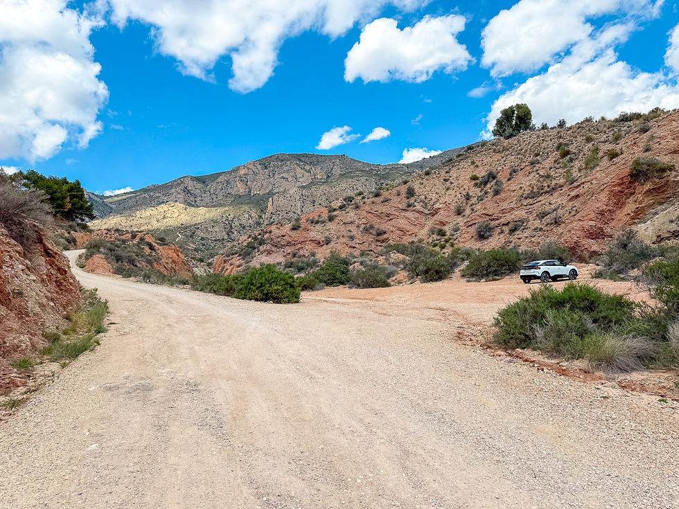
The route begins at the parking lot at Els Pontets. Continue on foot on the road straight ahead. After a couple of hundred meters you will come to a place where a path turns off to the right. This is the start of the route. Follow the markings on the path until you, after about 1 km, reach a peak where the first station on the route is located. Continue the path further up until you reach a gravel road. Turn right and continue a few hundred meters up to the place where most of the excavations are.


An alternative route is to continue on the road into the valley. This is a bit longer, but more pleasant because you will be walking on a gravel road all the way to the top. After 1 km, turn right from the main road and enter a parking lot. From there, a gravel road leads into a disused quarry. Continue through the quarry and further up the gravel road at the other end. After about 1.7 km, you will reach the archaeological excavations. The quarry itself is worth a visit. Gypsum and clay have been extracted here. The clay was used to produce bricks. The desert-like landscape around provides a beautiful setting for the red quarry.
To see as much as possible, you can walk up the path and then down the gravel road again, making a round trip.


As a curiosity, it can also be mentioned that there have been two film shoots in the disused quarry. The first was from October 12 to November 13, 2020 when scenes from the Spanish film Espíritu Sagrado by director Chema Garcia Ibarra were shot. It was a dark science fiction thriller about ufologists, a secret plan that would change the world, a daughter who went missing, conspiracies and supernatural mediums. Most of the film was shot in the nearby city of Elche. It only had amateur actors from the local community and is therefore described as UFO-popular.
From July 22 to 29, 2024, the quarry was used by a French film crew to shoot parts of a series called Néro - or Néro the assassin, an action-adventure that dealt with dramatic events during a drought in southern France in the year 1504. Néro was a dangerous assassin who was betrayed by his former master. He abandoned his daughter Perla when she was a newborn, but in the film he sets out on a journey to protect her from enemies and evil forces. With him on the journey is an old monk and his master's daughter, who was also engaged to a prince. He has to overcome many challenges, there is action, adventure, conspiracies and historical drama. Eventually Néro becomes an antihero who dedicates himself to fighting for good.
In both films, the semi-desert landscape of the area is an important ingredient.


The area around the Els Pontets car park is also interesting. Here you can see aqueducts that have been channelling water from underground rivers in the mountains down to agricultural areas in the lowlands for centuries, a technology borrowed from the Middle East. The network of underground aqueducts - called Qanats - and the lower level of the aqueduct on the bridge over the road were built in the 13th century, while the upper level of the bridge was built in the early 1900s. The system was in use until the end of the 20th century when the source from which the water was drawn was closed. After this, the aqueducts gradually fell into disrepair until work was started in 2006 to rehabilitate them. Els Pontets is a listed building and is considered important because it shows buildings from two eras. The word pontets means the little bridges.


More excursions: www.turideer.com
Excursion of the week: Herna at Peña Negra Crevillente - archaeological route
Length: The longest route from the car park at Els Pontets to the top of the excavations (354 m) via the disused quarry (290 m) is approx. 2.8 km long. From here to the viewpoint (467 m) it is a further 0.7 km. The entire route is 7 km long there and back, or 5.6 km if you do not go up to the viewpoint. If you choose the path, the route is 0.5 km shorter each way. The entire route is 6 km long there and back, or 4.6 km if you do not go up to the viewpoint.
Suitable for: The hike up to the archaeological excavations is an easy route that most people will be able to manage. There is a roadblock with a chain at the start, but it should be possible to pull a stroller or wheelchair past. If you follow the gravel road, you will get a steady and relatively gentle climb. If you choose to walk the trail, there are some steeper sections that can be strenuous, but are not technically difficult or dangerous. The hike from the archaeological excavations to the viewpoint at the top of Peña Negra is quite steep, but not technically difficult. Those with a strong fear of heights may find it uncomfortable to walk a short distance where there is a steep slope next to the trail, but it is at least 2-3 meters to the edge, and it is not dangerous at any point.
How to get there: Type "Els Pontets" in Google Maps. This will take you straight to the small parking lot by the aqueducts. Alternatively, you can type "Jaciment Arqueologic de Penya Negra" in Google Maps. This will take you straight to the disused quarry.


Comments